Page 1 of 1
Module Statistiques ?
Posted: 22 Mar 2020, 07:51
by F1NQP
Bonjour.
Sur la V1, il était possible de voir les statistiques des pays ou grands carrés locator contactés, puis de les afficher sur une map.
Nous avons cherché sur le V2, et il semblerait que cette option n'y est plus.
Qui aurait une information ?
73 à tous et bon Dimanche.
Good morning, sir.
On the V1, it was possible to see the statistics of the countries or large locator squares contacted, then to display them on a map.
We've searched on V2, and it seems that this option is no longer there.
Who would have any information?
73 to all and happy Sunday.
Re: Module Statistiques ?
Posted: 22 Mar 2020, 08:25
by DF5WW
That was the KML support for Google Earth you mean. That is not implemented yet in
actual V2. Sooner or later it will be back i think. If you like to see your worked/confirmed
locators on a Google Map you may use for now the online Gridtracker of WG7J:
http://wg7j.reinalda.net/gridmapper/gridmapper.php
You can export filtered (by Band) ADIF files from QSO-Manager and upload it to the gridtracker
site. Then it will create a map for you. The owner wrotes that ADIF 2 is needed but i tested
with ADIF 3 from Log4OM V2 and it works too. Here a screener of my 6m locators:
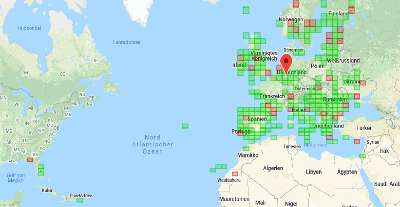
- 1.png (115.61 KiB) Viewed 4145 times
Re: Module Statistiques ?
Posted: 22 Mar 2020, 14:51
by F1NQP
Merci pour cette info Juergen.
De mon côté, en attendant le retour de ce module dans la version 2, j'utilise ce site:
http://analyzer.adventureradio.de/
Puis j'utilise Adif Master pour filtrer le fichier adif, et ça donne de belles cartes et ça permet de voir son trafic.
73 qro et bon après-midi.
Thanks for this info Juergen.
For my part, while waiting for the return of this module in version 2, I use this site:
http://analyzer.adventureradio.de/
Then I use Adif Master to filter the adif file, and it gives beautiful maps and it allows you to see its traffic.
73 qro and good afternoon.
Re: Module Statistiques ?
Posted: 23 Jun 2020, 09:23
by M0ZEH
DF5WW wrote: ↑22 Mar 2020, 08:25
That was the KML support for Google Earth you mean. That is not implemented yet in
actual V2. Sooner or later it will be back i think. If you like to see your worked/confirmed
locators on a Google Map you may use for now the online Gridtracker of WG7J:
http://wg7j.reinalda.net/gridmapper/gridmapper.php
You can export filtered (by Band) ADIF files from QSO-Manager and upload it to the gridtracker
site. Then it will create a map for you. The owner wrotes that ADIF 2 is needed but i tested
with ADIF 3 from Log4OM V2 and it works too. Here a screener of my 6m locators:
1.png
Thanks I miss this feature. I'm coming from hrd logbook after many years. Shame it doesn't draw the line between your station and the others.
Thanks Steve M0ZEH